Geography

The Malaysia is a country headed, first between the peninsula Malay, connected to the Asian mainland, and two Eastern States, Sabah and Sarawak, North Borneo island - with, in between, a few islets scattered in South China Sea.
The peninsula, which is just 40% of the national territory, stretches over 740 km long and is emphasized in all its half North, the backbone of the chain of Titiwangsa, including major summits exceed 'only' the 2,000 m the highest point of the peninsula is detached: this is Mount Tahan (2,187 m), located in the heart of the national park Taman Negara - a goal of arduous trek but wanted.
The West coast of the peninsula, the most industrialized, is interspersed with mangroves. Inside of the land, it is the rainforest which dominates. On the eastern coastal plain, observed, ranging from North to South, from small swampy deltas alternating with sandy beaches. South of this same plain is a little flatter and you can meet some floodplain forests. It is in Borneo, Sabah, rises the highest point of the country: mount Kinabalu, which rose to 4,095 m.
Climate
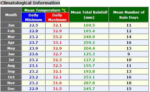
The Malay peninsula has an equatorial climate marked by constant heat and humidity.
There are sides, more sunny and refreshed by oceanic influences (26-29 ° C sea water), low in the hinterland, more stifling land. Added to this, North of Kuala Lumpur, upland marrying the flanks of the Titiwangsa chain. There, thanks to the altitude, it can do almost fresh.
Everywhere abundant rainfall (2500 mm of average annual, or four times more than in Paris!), but then again, with significant variations. The country has two monsoon periods, stretching almost the entire year.
-(Winter monsoon) northeast monsoon: the more intense of the two, she is from November to March and brings rains particularly supported on the coast of the peninsula and in coastal areas of Sabah and Sarawak (Borneo). She also sprinkles the Centre and Coast West, but significantly less significantly.
-(Summer monsoon) southwest monsoon: it dominates from late May to September and sweeps the coast West, but with less rainfall than those on the coast winter monsoon is. It is often accompanied by "coups de Sumatra" (winds).
Clothes away
It can rain anytime, but showers are generally brief and violent. Still provide a Mac kind poncho, especially if you go into the jungle. Small wool recommended for the Cameron Highlands and other stations. Otherwise, light, cotton clothing, for the whole country.
The seasons to avoid
Several periods to avoid:
-the months from November to late February on the coast is. It rains a lot and links by boat to the Islands are very random, or non-existent;
-the months from November to mid-January for the Taman Negara national park. Rain and school holidays programme;
-Chinese new year across the country, because all the hotels are very expensive and may not be complete;
-ramadan, including the date changes each year. In this period, activities idling, many restaurants are closed, and the atmosphere turns out to be not conducive to trade;
-Finally, please be aware that the Malays are taking their holidays in December. Better to make reservations.
Environment
The frantic economic development of the Malaysia is hardly embarrassed ecological data. Major projects redraw the territory without shame, mines pollute rivers, and industrialization is, as everywhere, synonymous with pollution and carbon dioxide emissions increased - particularly in the areas of Selangor, Perak and Johor Bahru. The population itself lack of education on the subject and cares little waste piling gradually in most visited places.
The major problem remains that of deforestation. Areas that had not yet been cut to make way for rubber plantations are being developed for developing huge industrial farms of palm oil. Today the most widely consumed in the world, it offers exceptional performance. Palm oil is produced in 85% by the Malaysia and the Indonesia.
On paper, all is well: when we look at figures of the Government or NGOs, we can read that the forest still covers between 56 and 63% of the national territory. It is much more than in Western Europe. Remains that the vast expanses covered with oil palm and rubber are included in this figure, which partly false the value. Green, Yes, but more a lot of biodiversity in these chemically treated areas... Primary forests,
No comments:
Post a Comment